
Gujarat Wethar Updates: આ વિસ્તારોમાં 17 ઇંચ સુધી પડી શકે છે વરસાદ! નદીઓમાં પૂર,
It has been raining heavily in the state for the last four-five days, recently the Meteorological Department has given another big forecast, which is that more than 8 districts of the state may experience heavy to very heavy rains today. It includes most of the districts from South Gujarat to Saurashtra-Kutch. After the forecast, the system has also gone into alert mode. Apart from this, forecaster Paresh Goswami has predicted up to 17 inches of rainfall in these areas due to the calamity coming from the Arabian Sea.
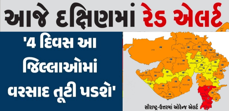
A deep depression has already formed in the Arabian Sea. This deep depression is going to pass through Gujarat. Because of this, there are chances of heavy rain in Dwarka, some parts of Porbandar, Jamnagar, Morbi, Surendranagar, Ahmedabad, Viramgam, Mandvi, Kandla, Gandhidham, Bhachau, Bhuj till evening on July 2. Thus, especially Ahmedabad, Gandhinagar are also included.
From the beginning of the Jeth month of the Gujarati calendar, a cloud begins to gradually form in the Abha Mandal. Farmers and herdsmen, animals and birds are waiting for the rain. However, this time the rains stopped in Kerala. Where the rains continued after the investment. It is currently raining in many districts. Due to which some districts are witnessing water-bombing situation. According to the reports received by the State Emergency Operation Center of the state today. On 02/07/2024, 143 talukas of the state received significant rainfall during 24 hours from 6.00 am. There are 32 taluks in which there are reports of more than 04 inches of rain.
Forecaster Paresh Goswami has predicted up to 17 inches of rain in these areas due to the calamity coming in from the Arabian Sea. A deep depression has already formed in the Arabian Sea. Also, he has given information about where this deep depression will pass and what will be its effect, which districts are likely to receive heavy rain. Also, moderate to heavy rains are likely over Aravalli, Mahisagar, Mehsana, Patan, Banaskantha areas. Dahod, Godhra, Vadodara, Kapdwanj, Anand, Nadiad, Kheda of central Gujarat have normal to moderate rain chances. There will be continuous rain in the districts of South Gujarat. While moderate to heavy rain will continue in rest of the districts of Saurashtra.
Areas like Dwarka, Junagadh, Jamnagar, Surendranagar, Kandla of Kutch, Gandhidham, Bhachau, Mandvi, Ahmedabad, Gandhinagar, Viramgam, Sanand in central Gujarat are likely to receive above normal rainfall during this period. In the districts which have been named, there is a situation where there may be 15 to 17 inches of rain in some areas. Because, deep depression is going to go through this route. There are chances of heavy rainfall in these areas. Rains are likely over Gujarat, but heavy rains are likely over areas where the deep depression is expected to pass. This round of universal rain is to continue for several more days.
Next 5 days rain forecast in the state
Heavy rain is predicted in the state for the next 5 days. In which heavy rain will fall in Rajkot, Jamnagar, Amreli, Bhavnagar, Morbi, Junagadh. Therefore, the fishermen have been instructed not to plow the sea for the next 5 days. Cyclonic circulation has become active over South Gujarat and North Gujarat. Last June, there was a 12 percent decrease in rainfall. 118 mm of rain was expected in June. Against this, 104 mm of rain was recorded.
Forecaster Ambalal Patel’s prediction has also come. He said that if it rains in Sravana Panchak, then there will be good rain. It is considered a good sign that Panchak starts raining in Gujarat. Heavy rain in most parts of the state this morning is an indication of the arrival of monsoon. Good rains are likely between July 4 and July 8. There will be good rain in the state during the Rath Yatra as well. The setting sun is likely to remain in the clouds.
In the last week of June, the rains have come down. Rain has been reported everywhere in Gujarat as if a cluster of stuck clouds has suddenly rushed towards Gujarat. Monsoon has entered from East and Bay of Bengal. Clouds are now coming down from the north of India, which collide with the eastern clouds and reach the Arabian Sea and meet again with the westerlies on the way to Gujarat, Maharashtra.
Clouds in the Arabian Sea are reaching Muscat and dispersing back towards India. So heavy rain is predicted in Mumbai in the coming days. Its impact will be seen from southern Gujarat to the western part of Madhya Pradesh. Due to this atmospheric equation, there will be a tremendous change in the atmosphere of Gujarat in the first week of July. Due to this there will be torrential rain in Gujarat.